
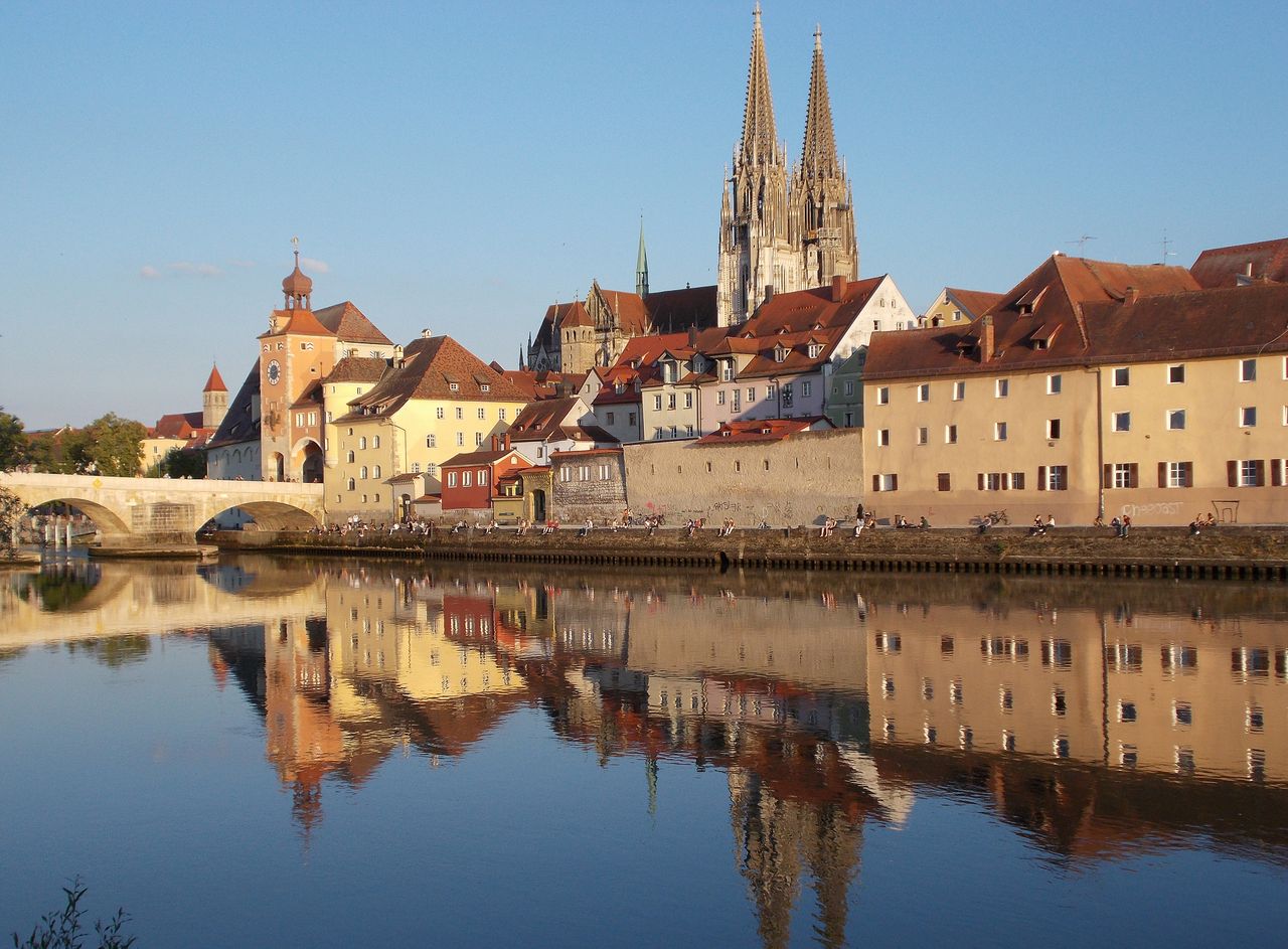
Updated in August 2026 — this article has been fully revised and substantially expanded, with the latest German government data on the Regensburg flood risk case, reframed for U.S. readers evaluating their own flood exposure and protection strategy.
Regensburg’s flood protection spending isn’t happening in isolation — it’s one piece of a much larger state-level commitment. Bavaria has invested roughly €4 billion in flood protection since 2001, building over 190 kilometers of new levees and rehabilitating 340 kilometers of existing ones. The state’s current program, “PRO Gewässer 2030,” commits a further €2 billion through 2030 — about €200 million per year — with a stated goal of bringing 100-year flood protection to an additional 150,000 Bavarian residents by the end of the decade.
Quick answer: Regensburg’s Danube flood record has broken three times since 1988 (6.59m ? 6.70m ? 6.81m in 2013), and German climate scientists attribute this escalation partly to climate change, which they estimate made the 2013 flood roughly 10 times more likely. The city is still building new flood defenses in 2026, with a €55 million project completing no earlier than 2031.
Climate change and flooding are reshaping risk even in historic river cities with centuries of accumulated flood management experience. Regensburg, Germany — a UNESCO World Heritage city at the confluence of the Danube and Regen rivers in Bavaria — is one of the best-documented case studies available anywhere in Europe, precisely because German authorities have spent over a decade running formal climate attribution studies, publishing detailed hydrological records, and building out flood infrastructure in full public view. For U.S. facility managers and homeowners evaluating their own flood exposure, Regensburg’s experience is a rare opportunity to see, in granular detail, what happens when climate change measurably compresses the return period of extreme floods faster than a well-funded city can build defenses against them.
This matters well beyond Germany’s borders. The same physical mechanism driving the Danube’s rising flood levels — a warmer atmosphere holding more moisture, released as heavier and more concentrated rainfall — is the mechanism behind the flooding our own research documents in heavy rainfall and flooding trends across the U.S. Regensburg simply gives us more data, collected over a longer period, with more rigorous attribution science behind it, than most American case studies currently offer.
Key takeaways
- Regensburg has broken its own flood record three times since 1988 — 6.59m in 1988, 6.70m in 2002, and 6.81m in June 2013 — a pattern of escalation, not a single outlier event.
- Germany’s national weather service (DWD) ran a formal climate attribution study and concluded that climate change made the 2013 flood roughly 10 times more likely, compressing its statistical return period from once every 40 years to once every 30.
- German water law (§78 of the Wasserhaushaltsgesetz) imposes a strict building ban inside designated floodplains — one of the strongest legal tools available anywhere for keeping new construction out of harm’s way, and a useful comparison point for U.S. floodplain zoning.
- Germany is actively debating a national mandatory flood insurance requirement in 2026, driven by the fact that 57% of German residential buildings currently carry no flood or heavy-rain coverage at all — a gap with direct parallels to underinsurance in U.S. flood zones.
- Regensburg is still under active construction in 2026, with a €55 million flood wall project on the inhabited Unterer Wöhrd island alone — a reminder that even well-funded, decade-plus infrastructure programs leave individual properties needing their own protection in the meantime.
Table of Contents
Climate change and flooding: the Regensburg case study
Regensburg sits at the confluence of the Danube and Regen rivers in Bavaria, Germany — a location that has shaped the city’s flood exposure since its founding as a Roman legionary camp nearly 2,000 years ago. The Danube here drains a large upstream catchment across southern Germany and Austria, which means that sustained rainfall anywhere across that basin — not just locally — can push the river to dangerous levels days later in Regensburg itself. This is structurally similar to how large U.S. river systems like the Mississippi or Missouri accumulate flood risk from rainfall hundreds of miles upstream.
What makes Regensburg’s flood record unusually valuable for analysis is that it isn’t a single dramatic event — it’s a documented, escalating sequence spanning nearly four decades.
Regensburg’s escalating Danube flood records, 1988–2013
1988
6.59 m
2,530 m³/s flow
2002
6.70 m
new record
2013
6.81 m
current record
Source: Bavarian State Flood Information Service (hochwasserschutz-regensburg.bayern.de) historical flood chronicle.
Each of these three events broke the previous historic high-water mark. In March 1988, the Danube reached 6.59 meters at the Regensburg gauge with a peak discharge of 2,530 cubic meters per second — at the time, the highest level recorded in the modern gauge record. Just 14 years later, in August 2002, the same stretch of river reached 6.70 meters. And in June 2013, following days of sustained rainfall driven by a slow-moving atmospheric river pattern across Central Europe, the Danube hit a new record of 6.81 meters — 22 centimeters higher than the 1988 mark, and the highest level ever recorded at this gauge.
The 2013 flood was not an isolated German event — it was part of a broader Central European flood catastrophe that also devastated parts of the Czech Republic, Austria, and Poland during the same week. Bavaria-wide, the damage bill reached an estimated €1.3 billion, including €111 million in damage to existing flood protection infrastructure itself — a sobering reminder that flood defenses can be damaged or overtopped by the very events they’re designed to stop.
What the climate attribution science actually shows
The most rigorous part of the Regensburg case study isn’t the flood itself — it’s what happened afterward. Germany’s national weather service, the Deutscher Wetterdienst (DWD), conducted a formal climate attribution study on the 2013 event and the broader pattern of Bavarian flooding, using the same statistical methodology increasingly applied to extreme weather events worldwide, including by U.S. research teams analyzing events like the 2021 Ahr Valley flood in western Germany.
Attribution science works by comparing the observed frequency of an extreme event against a modeled “counterfactual” world without human-caused climate change, then calculating how much more likely the real event was given actual atmospheric conditions. The DWD’s conclusion for the Bavarian flood pattern: climate change made an event on the scale of the 2013 Danube flood roughly 10 times more likely than it would have been in a pre-industrial climate. In practical terms, that means the statistical return period for a flood of this magnitude has compressed from an event expected once every 40 years to one now expected once every 30 years — and DWD researchers caution that further warming will likely compress that further.
There’s a second, independent piece of evidence pointing the same direction: official planning documents for Regensburg’s flood infrastructure state that a modern 100-year flood event (“HW100” in German planning terminology) would now be expected to reach a water level roughly one meter higher than the 1988 flood — a level far exceeding even the 2013 record. That single planning assumption, built directly into the engineering specifications for Regensburg’s current flood walls, is itself a quiet acknowledgment that historical flood records are no longer a reliable ceiling for future risk.
Why this matters for U.S. flood risk assessment
If a modern 100-year flood in Regensburg is now projected to exceed the actual record set just 13 years ago, the same logic almost certainly applies to river systems across the U.S. Our guide on determining your home’s flood risk explains why relying purely on historical FEMA flood maps, without accounting for this kind of climate-driven compression, can understate real exposure.
The legal framework: Germany’s strict floodplain building ban
One structural difference between German and U.S. flood policy is worth understanding, because it shapes how a city like Regensburg actually manages risk at the property level. Under §78 of the German Federal Water Act (Wasserhaushaltsgesetz, or WHG), new construction, expansion, or modification of buildings is legally prohibited inside officially designated flood zones — not merely discouraged through insurance pricing or building code requirements, as is more typical in U.S. floodplain management, but banned outright as a matter of federal water law.
Property owners inside Regensburg’s designated Danube and Regen floodplains who want to build even modest additions — a dormer window, a rooftop extension, a carport — must apply for a formal exemption (“wasserrechtliche Ausnahmegenehmigung”) from the city’s environmental office, and that exemption is only granted under specific conditions that don’t worsen flood risk for the surrounding area. Even simple additions above the HW100 line, like balconies or awnings, require formal notification to the city.
This stands in fairly sharp contrast to how many U.S. jurisdictions handle Special Flood Hazard Areas, where construction is typically still permitted provided it meets elevation and floodproofing requirements under the National Flood Insurance Program, rather than being prohibited by default. The German approach trades flexibility for a much lower baseline of new exposure — but it does nothing to reduce the risk already embedded in centuries of existing construction along the Danube, which is precisely why the infrastructure and insurance questions below matter so much in Regensburg’s case.
How Regensburg is responding — and what it costs
Following the 2013 flood, Bavaria and the city of Regensburg accelerated a long-running, multi-decade flood protection program covering both the Danube and Regen riverfronts. This isn’t a single project but a portfolio of separate, overlapping efforts, each with its own budget, timeline, and engineering approach.
In November 2022, officials completed a roughly one-kilometer stretch of combined walls, mobile barrier elements, and steel sheet piling near the Westhafen district, with some structural elements anchored up to eight meters into the ground to prevent underground seepage during high water. That project alone protects an estimated 5,000 residents from a 100-year flood event and cost approximately €10 million.
That work is far from finished. As of 2026, a separate and considerably more complex project is under construction on the Unterer Wöhrd — an inhabited island in the middle of the Danube within Regensburg’s city limits, which by definition cannot be protected by a simple continuous levee without effectively walling in an entire residential neighborhood. This project is now budgeted at approximately €55 million, with a five-year construction timeline, and is cost-shared 80% by the Bavarian state government and 20% by the city of Regensburg itself. Local reporting has noted that the project’s planners are already grappling with cost escalation typical of major infrastructure work — a pattern familiar to anyone tracking similar U.S. coastal or riverine flood-control megaprojects.
Regensburg’s broader flood protection strategy also incorporates ecological retention measures alongside hard infrastructure — an approach increasingly common in modern flood management because it addresses both flood peaks and habitat loss simultaneously. An 800-meter riverbank restoration project, completed in 2015–2016 at a cost of roughly €725,000, was specifically designed to both store floodwater during high-water events and restore natural riparian habitat along the river corridor.
| Project | Cost | Status | Approach |
|---|---|---|---|
| Westhafen wall/barrier system | ?€10 million | Completed 2022 | Hard infrastructure: walls, mobile barriers, sheet piling |
| Unterer Wöhrd flood wall | ?€55 million | Under construction, 2026, ~5-year build | Hard infrastructure protecting an inhabited river island |
| 800m riverbank retention area | €725,000 | Completed 2015–2016 | Ecological retention and habitat restoration |
The lesson for U.S. property owners
Regensburg has spent well over a decade and tens of millions of euros incrementally hardening its flood defenses since the 2013 record flood — and the work still isn’t complete. That timeline is typical for large-scale municipal flood infrastructure anywhere, including comparable U.S. river and coastal flood-control projects. In the meantime, individual buildings inside and outside the officially protected perimeter still need their own protection. Our guide to flood protection systems for your home covers options that don’t require waiting on multi-year public works timelines.
The flood insurance gap: a warning sign, not just a German problem
Perhaps the most striking parallel to the U.S. flood insurance situation is unfolding in Germany right now, in real time, as this article is being updated. Standard German homeowners insurance (Wohngebäudeversicherung) covers fire, storm, hail, and water damage from burst pipes — but explicitly excludes damage from flooding, heavy rain, and landslides unless the policyholder has purchased a separate add-on called “Elementarschadenversicherung” (elemental damage insurance). This is structurally almost identical to how standard U.S. homeowners insurance excludes flood damage, requiring a separate NFIP or private flood policy.
The scale of the resulting coverage gap in Germany is real, though smaller than it once was: according to the German Insurance Association (GDV), 59% of German residential buildings carried Elementarschadenversicherung coverage as of end-2025 — up sharply from just 41% in 2017 — which means roughly 41% of German homes still have no flood or heavy-rain coverage at all. This gap became a major political issue following the catastrophic 2021 Ahr Valley flood, which killed at least 135 people and left many uninsured homeowners facing complete financial ruin. As a direct result, German federal and state lawmakers have been actively debating a nationwide mandatory Elementarschadenversicherung requirement since a joint federal-state working group published its findings in February 2025.
As of this update, no mandatory requirement has been enacted. Premiums vary sharply by official flood risk zone (ZÜRS): homes in the lowest-risk zone pay under €150–300 per year for this coverage, moderate-risk zones pay roughly €200–350 per year, and homes in the highest-risk zones pay €1,000 to over €3,000 annually with a typical €500 deductible. Naturgefahren-related losses (storm, hail, flood, and heavy rain combined) cost German insurers roughly €1.4 billion in 2025 alone, with flood and heavy-rain claims specifically totaling about €400 million across 88,000 claims.
Why U.S. readers should watch this debate
Germany’s proposed shift toward default-inclusion flood insurance, with an opt-out rather than opt-in structure, is a policy experiment the U.S. has not yet run at national scale. If it moves forward, it could offer real-world evidence on whether automatic enrollment meaningfully closes the flood insurance gap — evidence directly relevant to ongoing U.S. debates about underinsurance in FEMA-mapped flood zones.
What this means if you own property near a river
Pulling together the flood chronology, the attribution science, the legal framework, and the insurance debate, Regensburg offers a genuinely instructive template for how U.S. property owners near rivers or in flood-prone regions should think about their own exposure.
- Historic flood records can understate future risk — sometimes by a wide margin. Regensburg’s own 100-year flood planning standard now sits roughly a meter above its actual 1988 record. If your area’s flood zone designation is based purely on historical data without a climate-adjusted projection, it may already be outdated. See our guide on determining your home’s flood risk to check whether your local data reflects current climate trends.
- Municipal protection takes years, sometimes decades, even with strong funding and political will. Regensburg’s Unterer Wöhrd project alone spans five years of construction, on top of over a decade of prior work — a reminder that public infrastructure timelines rarely match the urgency of individual household risk.
- Don’t assume your insurance covers flood damage by default. Just as German homeowners insurance excludes flood damage without a separate Elementarschadenversicherung add-on, U.S. homeowners insurance excludes flood damage without a separate NFIP or private flood policy. The 57% German coverage gap is a warning about how easy it is to assume coverage that doesn’t actually exist.
- Layer building-level protection with insurance rather than choosing one or the other. Combining automatic flood barriers with adequate flood insurance addresses both the physical and financial sides of river flood exposure while larger public infrastructure projects are still being completed.
- Watch how strict floodplain construction rules evolve in your own area. Germany’s outright building ban under WHG §78 is stricter than most U.S. floodplain regulation, but the underlying logic — that new construction in known flood zones compounds future risk and cost — is increasingly informing U.S. floodplain policy discussions as well.
Conclusion at a glance
The pattern
Three record floods since 1988 (6.59m ? 6.70m ? 6.81m) show escalation, not a one-off anomaly.
The science
DWD attribution study: climate change made the 2013 flood 10x more likely; the 100-year standard now exceeds the actual record.
The infrastructure
€10M completed in 2022; €55M project still under construction in 2026 with a five-year timeline.
The insurance gap
57% of German homes carry no flood coverage — a mandatory-insurance debate is active in 2026.
What to take away
Even a well-funded, legally strict flood management program takes decades to build out fully, and insurance coverage gaps persist even in a country with strong flood-risk awareness. Building-level protection and adequate insurance both remain necessary, in Regensburg and in any U.S. flood-prone location, regardless of how much collective infrastructure exists.
FAQ
Why is Regensburg a useful flood case study for U.S. readers specifically?
Regensburg offers an unusually complete data set: a nearly 40-year documented flood record showing three escalating record events, a formal government climate attribution study quantifying how much climate change increased flood probability, a strict legal floodplain framework, and an active national insurance policy debate — all publicly documented. That combination of depth and transparency makes it a more instructive case study than most single-event U.S. examples.
How much worse has Regensburg’s flood risk actually gotten?
The Danube’s recorded flood peak at Regensburg rose from 6.59 meters in 1988 to 6.70 meters in 2002 to 6.81 meters in 2013 — three consecutive record-breaking events over 25 years. Official planning documents now assume a modern 100-year flood would reach roughly one meter higher than the 1988 level, exceeding even the 2013 record.
What did Germany’s climate attribution study actually conclude?
The German Weather Service (DWD) found that human-caused climate change made an event on the scale of the 2013 Danube flood roughly 10 times more likely than in a pre-industrial climate, compressing the statistical return period from once every 40 years to once every 30 years, with further compression expected as warming continues.
Does Germany prohibit building in flood zones?
Yes, more strictly than most U.S. jurisdictions. Under §78 of the German Federal Water Act, new construction and most modifications to existing buildings are legally banned inside officially designated floodplains, with narrow exemptions granted only under specific conditions. This differs from the more common U.S. approach of allowing construction if it meets elevation and floodproofing standards.
Is flood insurance mandatory in Germany?
Not yet, as of this update. A mandatory flood and heavy-rain insurance requirement (Elementarschadenversicherung) has been under active debate since a joint federal-state working group reported in February 2025, driven by the fact that roughly 41% of German homes still carry no such coverage even though the insured share has risen from 41% in 2017 to 59% by the end of 2025. No enactment date has been set.
What should U.S. property owners near rivers take away from Regensburg’s experience?
Three things: historic flood records can meaningfully understate future risk once climate change compresses event probability; large-scale municipal flood infrastructure can take a decade or more to complete even with strong political will and funding; and flood insurance is never automatic under a standard homeowners policy, whether in Germany or the U.S. Building-level protection combined with adequate insurance remains the most reliable way to close the gap while public infrastructure catches up.
About the author
Josef Anhamm is Managing Director of anhamm Liquid Barrier Products GmbH, headquartered in Moers, Germany, with U.S. operations based in Webster, NY. This family-owned company has developed and manufactured mechanical retention systems for firewater, hazardous substances and floods for over 30 years, deployed in more than 42 countries.
This article was originally published in 2025 and fully updated and expanded in August 2026 with current data on the Regensburg Danube flood protection program, German climate attribution research, floodplain law, and the ongoing national flood insurance debate.
Sources and further reading
- DWD climate attribution study on Bavarian flooding — Bayerischer Rundfunk
- Historic flood chronicle 1988–2013 — Bavarian State Flood Protection Program
- Regensburg flood protection expansion — Die Zeit
- Unterer Wöhrd flood wall project — Regensburg Digital
- 2013 Danube flood technical data — Bundesanstalt für Gewässerkunde
- Floodplain building permit requirements — City of Regensburg
- Germany’s mandatory flood insurance debate — Süddeutsche Zeitung
Related Spillbarrier articles
- Heavy Rainfall and Flooding: Climate Impact on U.S. Facilities
- Climate Change Flooding: New Challenges for Industrial Facility Safety
- Flood Protection for Your Home and Garden (2026 Guide)
- Flood protection systems for your home: which one is right?
- Ahr Valley Flood 2021: Key Lessons for Flood Protection

