The 2021 Ahr Valley flood was one of the deadliest natural disasters in modern German history, killing at least 135 people and causing over $45 billion in damages. The primary causes were extreme rainfall from Storm Bernd (over 3.5 inches per hour for 48 consecutive hours), saturated soils, the narrow valley topography of the Ahr River, and critical failures in early warning communication. For American homeowners, municipalities, and infrastructure planners, the lessons from this disaster are directly applicable — the same combination of climate-driven rainfall, inadequate flood protection systems, and failed early warnings is playing out across the US every hurricane and storm season.
This article is written for homeowners, local governments, and decision-makers who want to understand the causes and consequences of extreme flood events — and learn what modern flood protection systems can do to prevent the next disaster. It provides evidence-based analysis to help assess risk and implement the right protective measures before the next storm hits.
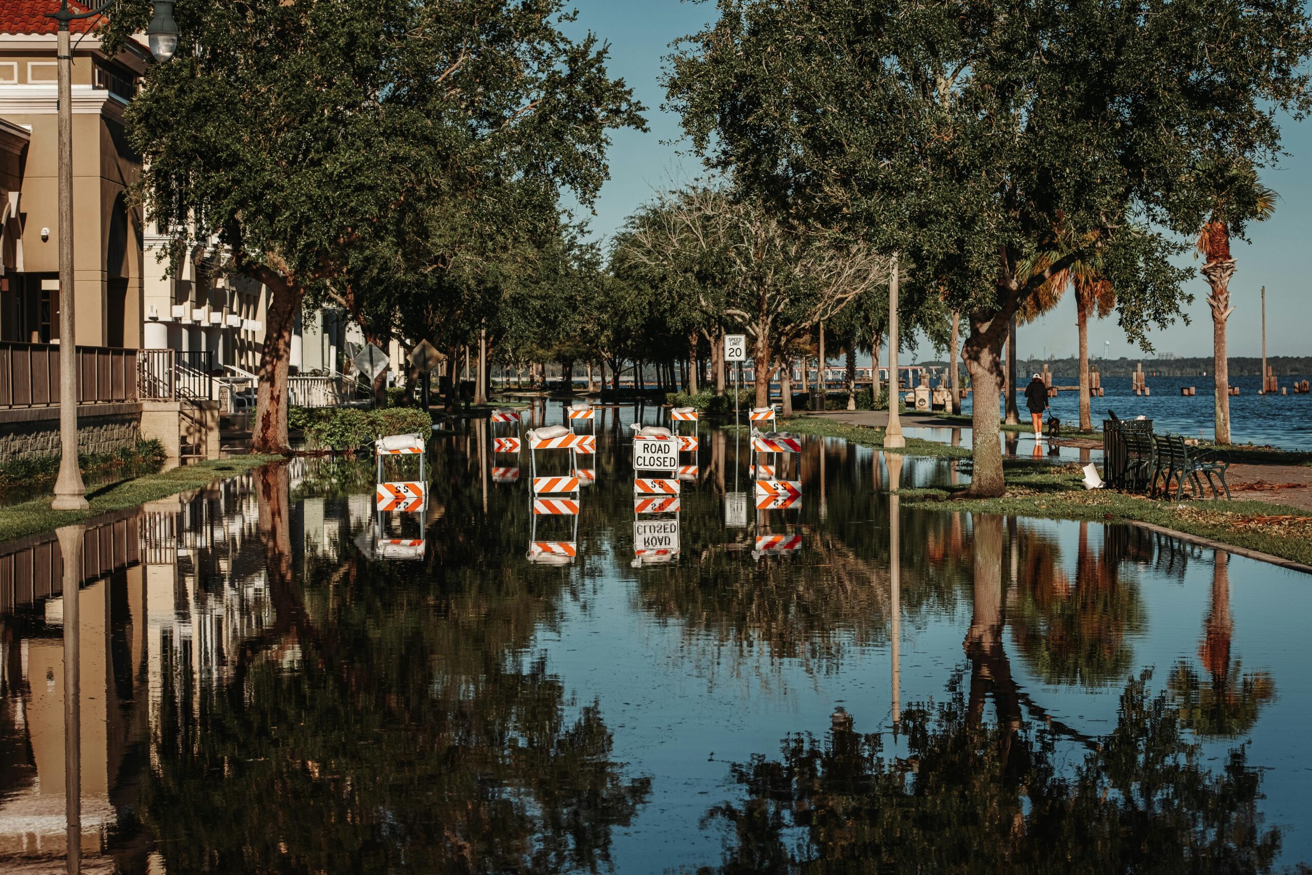
Photographs and aerial imagery played a crucial role in documenting the scale of the Ahr Valley catastrophe, driving public awareness and informing reconstruction policy. A single image of a parking lot, a collapsed bridge, or a submerged town communicates what data alone cannot — the urgency of building flood resilience before disaster strikes, not after.
On July 14, 2021, the Ahr Valley in western Germany experienced a flash flood of catastrophic scale. What began as heavy rainfall rapidly became one of the worst natural disasters in post-war German history, killing over 135 people and causing more than $45 billion in damage. A detailed account by researcher Maik Jansen documents the infrastructure collapse and long-term consequences across the affected region.
The scientific analysis of this event is critical for developing better prevention strategies — not just in Germany, but in every flood-prone country. The Ahrweiler district in Rhineland-Palatinate became a case study in what happens when extreme weather intersects with inadequate flood protection systems and failed crisis communication. The Koblenz region serves as a parallel example of where effective water management helped limit damage.
The disaster exposed fundamental weaknesses in flood protection infrastructure, emergency management, and early warning systems. The specific dangers of flash flooding along small rivers — a hazard increasingly amplified by climate change — were made devastatingly clear. Research from the Helmholtz Centre for Environmental Research (UFZ) and scientists including Prof. Dr. Wolfgang Brauner and Christian Kuhlicke has since provided critical insights for improved flood resilience frameworks.
This article provides a comprehensive analysis of the following:
- Meteorological, hydrological, and structural causes of the Ahr Valley flood
- Communication failures and emergency management breakdowns
- The role of climate change in increasing flood frequency and intensity
- Modern flood protection systems and technical solutions
- Lessons for crisis management and post-disaster reconstruction
- How automatic passive flood barriers provide fail-safe protection
Key Takeaways
- The Ahr Valley flood was the result of extraordinary rainfall from Storm Bernd, inadequate flood warnings, and structural deficiencies in flood protection infrastructure — a combination that is not unique to Germany.
- Scientific evidence from World Weather Attribution confirms that climate change made this rainfall event up to nine times more likely — a finding with direct implications for US flood risk planning.
- A comprehensive regional flood management plan — integrating retention basins, floodplain restoration, and municipal coordination — is the only sustainable path to long-term flood resilience. The Ahr Valley is now being studied as a model region for climate-adaptive reconstruction.
- Modern automatic flood protection barriers operate without electricity or human intervention, providing fail-safe protection when power outages and storm conditions make manual deployment impossible.
Causes of the 2021 Ahr Valley Flood
The July 14, 2021 flood was the result of multiple compounding factors — from extreme atmospheric conditions to organizational failures that stretched across multiple government levels. The following overview identifies the key causes:
Impervious surface coverage in the Ahr Valley was 40% above the regional average — dramatically accelerating runoff directly into the river.
Climate change increased the probability of this rainfall event by up to nine times compared to pre-industrial baselines — and the trend is accelerating.
In the aftermath of the flood, response actions by civil protection agencies were subjected to criminal investigation by state prosecutors. These investigations aimed to determine whether negligence or preventable failures contributed to the death toll. Both the Rhineland-Palatinate and North Rhine-Westphalia state governments established parliamentary inquiry committees to conduct a full political and organizational post-mortem of the disaster response.
Meteorological Causes
- Exceptionally intense and sustained rainfall in July 2021 (over 3.5 inches per hour for 48 hours)
- Saturated soils from an unusually wet spring — ground had zero remaining absorption capacity
- An anomalously stationary low-pressure system, Storm Bernd, stalled over Western Europe
- River gauge levels surged from under 3 feet to over 23 feet in a matter of hours
Meteorological analysis drew on data from official weather services and post-disaster scientific reports to reconstruct the full sequence of events.
Hydrological and Geographic Causes
- The Ahr’s narrow valley geometry accelerated water flow and created dangerous backwater effects
- Virtually no natural floodplain storage or retention areas in the catchment
- Small tributary rivers reached extreme velocities almost instantly during heavy rain
- Impervious developed surfaces throughout the valley prevented any ground absorption
What is impervious surface coverage? Impervious surfaces — roads, parking lots, rooftops, and developed land — cannot absorb rainfall. In the Ahr Valley, coverage was 40% above the regional average, meaning nearly all storm rainfall flowed directly into the river with no buffering. The same dynamic is accelerating flood risk across dense US suburbs and cities.
Structural and Planning Failures
- Insufficient flood protection infrastructure along smaller rivers like the Ahr
- Historic development within flood hazard zones that are now defined floodplains
- Absence of comprehensive contingency plans for extreme rainfall events
- No backup systems for river gauges, power supply, or communication infrastructure
Communication and Coordination Failures
- Early warnings from the European Flood Awareness System (EFAS) were not acted upon in time
- Official weather alerts and emergency notification apps reached the public too late
- River monitoring stations failed during the event — real-time data was lost precisely when it was most needed
- Coordination between local, state, and federal emergency response agencies broke down
On July 14, 2021, the Ahr Valley experienced one of the worst flood disasters in the modern history of any European nation. River gauges at Altenahr initially projected a peak water level of 17 feet — already far beyond the previous record of 12.2 feet set in 2016. By midnight, however, the actual water level reached an estimated 23 feet — a figure that exceeded every forecast and every historical precedent.
The spring of 2021 had been extraordinarily wet across western Germany, leaving soils fully saturated weeks before the disaster. According to the National Oceanic and Atmospheric Administration (NOAA) and parallel research by European meteorologists, this pre-saturation condition meant that when Storm Bernd delivered its extreme rainfall payload, the land offered virtually no absorption capacity — every drop flowed directly into the drainage system and rivers. Storm Bernd dropped rainfall totals over 48 hours that would normally be distributed across several months. The combination devastated towns and municipalities throughout Ahrweiler County and neighboring areas of North Rhine-Westphalia.
In the months following the disaster, a dedicated interdisciplinary task force was established to examine the full chain of causation — meteorological, structural, climatic, and organizational. The findings of this analysis are directly relevant to flood risk planning in the United States, where similar combinations of aging infrastructure, inadequate early warning systems, and climate-intensified rainfall are producing comparable catastrophes — from Hurricane Ida’s deadly flooding in New York City basements to record flash floods in Appalachian communities.
According to World Weather Attribution (WWA), the rainfall that caused the Ahr Valley flood was made 1.2 to 9 times more likely by human-caused climate change. Events of this magnitude are becoming the new normal — and flood protection systems must be designed accordingly.
Scientific Finding — World Weather Attribution
How Climate Change Intensifies Flooding

Climate change has a scientifically documented and measurable impact on both the frequency and severity of flood events. Since the 1950s, extreme precipitation events have increased in both frequency and intensity worldwide — a trend the Intergovernmental Panel on Climate Change (IPCC) directly attributes to global warming driven by greenhouse gas emissions.
The Physics Behind Heavier Rainfall
Clausius-Clapeyron relationship: For every 1.8°F (1°C) of atmospheric warming, the air can hold approximately 7% more moisture. When that moisture condenses, it falls as more intense precipitation. Rising ocean surface temperatures release additional water vapor into the atmosphere — further amplifying the intensity of future rainfall events. This is not a projection; it is a measured physical relationship.
Consequences for Flood Risk in the US
- More frequent and intense extreme precipitation events across all regions
- Longer drought periods followed by sudden extreme rainfall — ground cannot absorb the surge
- Shifting precipitation patterns — wetter winters, more intense summer convective storms
- Increased probability of flash flooding along small and mid-size rivers
- Earlier and more intense snowmelt in mountain watersheds feeding major rivers
The Ahr Valley flood of July 2021 was partially caused by extreme rainfall that climate change had made up to nine times more likely, according to World Weather Attribution (WWA). Their attribution study quantified how much human-caused warming shifted the probability and intensity of the storm. This methodology is now being applied to US flood events — including recent catastrophic floods in Kentucky, Vermont, and the New York metro area — with consistent findings: climate change is loading the dice toward more extreme outcomes.
According to the EPA’s Climate Change Indicators, heavy precipitation events across the contiguous United States have increased significantly since 1901, with the most dramatic increases occurring in the Northeast and Midwest. The frequency of record-breaking rainfall is accelerating — not slowing down.
US Environmental Protection Agency — Climate Indicators
Which US Rivers Face the Greatest Climate-Driven Flood Risk?
Small and mid-size rivers — particularly those draining steep terrain — are the most vulnerable to flash flooding from climate-intensified rainfall. Unlike the Mississippi or Ohio River systems, which respond to large-scale, multi-day precipitation patterns and provide longer warning windows, smaller rivers can rise from normal levels to catastrophic flood stage in under two hours. The Ahr Valley is a direct analog for hundreds of similar river valleys across Appalachia, the Ozarks, and the Mountain West.
- Small mountain and piedmont rivers (like the Ahr): Extremely vulnerable to flash floods from intense convective storms; reaction times measured in minutes, not hours
- Major river systems (Mississippi, Ohio, Missouri): Driven by large-scale, sustained precipitation or snowmelt; longer warning windows but massive damage potential
- Western mountain watersheds: Increasingly threatened by accelerated snowmelt, glacial retreat, and post-wildfire debris flows that amplify flood intensity
- Coastal and tidal rivers: Compound flooding from storm surge combined with riverine flood — a growing threat as sea levels rise along the Atlantic and Gulf coasts
A landmark study drawing on over 4,000 soil moisture and snowpack datasets from across Europe and North America documented a significant shift in flood seasonality driven by climate change — floods are arriving earlier in the year, at higher peak levels, and in regions previously considered low-risk. The implications for US flood zone mapping under the FEMA National Flood Insurance Program (NFIP) are significant: existing flood maps are increasingly outdated relative to actual risk.
The Role of Impervious Surfaces in Flash Flooding
The continued expansion of impervious surfaces — roads, parking lots, rooftops, and developed land — is dramatically worsening urban and suburban flood risk. When soil is sealed beneath concrete or asphalt, rainfall cannot infiltrate. Instead, it runs off immediately into stormwater systems and rivers, producing sharper and higher flood peaks. In the Ahr Valley, dense development along the riverbanks played a direct role in the catastrophic water surge.
Approximately 16% of the contiguous United States is covered by impervious surfaces — and the figure is growing in every metropolitan area. The flood consequences are measurable and well-documented:
- Reduced natural water retention in soils and shallow aquifers
- Accelerated stormwater runoff that overwhelms drainage infrastructure
- Higher and faster flood peak flows in downstream rivers and creeks
- Reduced groundwater recharge — compounding drought vulnerability between flood events
- Urban flash flooding in areas far removed from any designated floodplain
The combination of climate-intensified rainfall and increasing impervious surfaces is a multiplier effect — each factor makes the other worse. Nature-based flood protection strategies including floodplain restoration, urban green infrastructure, and permeable pavement programs are increasingly recognized by the EPA’s Green Infrastructure program as cost-effective complements to engineered flood protection systems. For individual structures and critical facilities, automatic water-activated flood barriers provide the last line of defense when water breaches broader protections.
The Flood and Its Consequences

The Ahr Valley flood had devastating consequences for infrastructure, the regional economy, and above all for the people who lived there. Floodwaters destroyed vast sections of infrastructure including roads, bridges, water and sewer systems, and buildings. Over 9,000 structures along a 25-mile stretch of the Ahr River were damaged or completely destroyed. Entire communities were cut off from the outside world; communication was possible only through emergency channels.
Remnants of destroyed structures and collapsed bridges remain visible in parts of the valley today — serving both as memorials to the disaster and as evidence of the reconstruction work still underway years later.
Material and Economic Damage
Total economic damages exceeded $45 billion, with insured losses alone reaching approximately $9.5 billion. The human cost was even greater: at least 135 people lost their lives, many more were injured, and a substantial portion of the surviving population experienced trauma requiring psychological support for years after the event. The scale of destruction mirrors what American communities have faced after major hurricanes and inland flood events.
Infrastructure Impacts
- Complete loss of electricity and drinking water supply across large sections of the valley
- Destruction of critical transportation infrastructure — multiple bridges collapsed entirely
- Severe damage to wastewater treatment plants and drinking water facilities
- Widespread soil contamination from spilled heating oil, chemicals, and sewage
- Complete failure of cellular, landline, and internet communications networks
Psychological Consequences
Many survivors experienced severe psychological trauma. Post-event studies found elevated rates of PTSD, anxiety disorders, and depression among flood-affected residents — with demand for mental health support persisting years after the event. Research from the Natural Hazards and Earth System Sciences journal documented these long-term mental health impacts in detail.
Communications Blackout
Cellular networks, landlines, and broadband internet failed across the flood zone — making coordination of rescue operations and public information nearly impossible for critical hours. This mirrors the communications failures seen during Hurricane Katrina and Hurricane Ida in the United States, underscoring the need for redundant emergency alerting systems.
This catastrophe made clear that the risks posed by extreme weather events are real, escalating, and require both governmental and individual action. The urgent need for robust crisis management frameworks and effective automatic flood protection systems at the property level was painfully underscored. For US homeowners and facility managers, the Ahr Valley is not a distant European tragedy — it is a preview of what inadequate flood preparedness looks like.
| Damage Category | Scale | Areas Affected |
|---|---|---|
| Human Lives Lost | At least 135 confirmed fatalities | Ahrweiler County and surrounding regions |
| Building Damage | Over 9,000 structures damaged or destroyed | Residential, commercial, and public facilities |
| Economic Damage | Over $45 billion total losses | Infrastructure, businesses, private households |
| Infrastructure | Hundreds of miles of roads, 62 bridges destroyed | Transportation, utilities, water treatment |
| Environmental Damage | Widespread soil and groundwater contamination | Agricultural land, nature reserves, waterways |
Flood Protection Systems: What Works

In response to the Ahr Valley disaster, a comprehensive regional flood management plan was developed covering the entire catchment area. Experts are increasingly calling for climate-resilient, nature-based flood protection measures that address the root causes of vulnerability rather than simply building higher walls. The plan aims to protect flood-prone communities by retaining water in the landscape long before it reaches populated areas — a philosophy increasingly endorsed by FEMA’s Hazard Mitigation program.
Core principle of the regional flood management plan: Large-scale retention measures must reduce the risk of catastrophic flood events significantly. The discussion of flood protection has fundamentally shifted: rivers need more room to expand naturally — not more concrete levees. This philosophy now underpins FEMA’s own guidance on floodplain management and the growing US movement toward freeing rivers from artificial constraints.
The plan includes the construction of large-scale flood retention basins. A total of 19 flood retention basins are planned across the Ahr catchment and its tributaries — considered the most effective engineered measures available for protecting the valley at scale. Higher bridge clearances and strengthened foundations are now standard requirements in the reconstruction plans. The concept of residual risk management — acknowledging that no protection system is absolute — has moved to the center of post-disaster planning discussions.
The Ahr Valley disaster triggered a fundamental shift in approach: away from purely reactive flood protection toward proactive risk reduction and land use adaptation. The focus has expanded to encompass entire river catchments rather than individual structures — moving away from concrete barriers toward nature-based solutions including floodplain restoration, reforestation, and wetland recovery. Experts are calling for floodplain areas to be kept clear of development, giving rivers the room to expand during high-flow events.
A critical voice driving this shift has been Prof. Dr. Wolfgang Büchs, a leading expert in sustainable flood management. His scientific work, interviews, and environmental analyses have consistently emphasized the importance of treating rivers as living systems with natural boundaries — not engineering problems to be contained. His advocacy for nature-based solutions and his insistence on giving rivers more space has significantly shaped the planning discussions and reconstruction priorities in the Ahr Valley.
In addition to the retention basins, approximately 1,000 river restoration measures are planned across the Ahr and its tributaries. These include:
- Removal of artificial bank reinforcements and creation of natural flood storage areas
- Restoration of riparian floodplains and wetlands as natural retention systems
- Reforestation of hillside catchment areas to improve soil water retention
- Creation of infiltration zones and de-paving of developed surfaces where feasible
- River channel optimization to reduce peak flow velocities during flood events
Nature-based flood protection measures — including wetland and floodplain restoration and natural floodwater storage areas — are increasingly recognized as some of the most effective and durable long-term solutions available. These approaches are subject to ongoing evaluation and refinement as new scientific findings and engineering innovations emerge. In the US, the USDA Natural Resources Conservation Service (NRCS) emergency watershed protection programs reflect a similar philosophy.
Natural Retention
Floodplain and wetland restoration creates natural water storage that absorbs flood peaks, reduces downstream surge, and strengthens ecosystem resilience simultaneously.
Engineered Basins
The 19 planned retention basins can store large volumes of water and release it in a controlled manner — dramatically reducing peak river flows during extreme events.
Property-Level Protection
Automatic flood barrier systems protect critical infrastructure and individual buildings directly — fail-safe, power-independent, and requiring no human action.
Automatic Flood Barriers: Property-Level Protection
Modern automatic flood protection barriers offer energy-independent protection that activates without human intervention — a critical advantage when the same storm that causes flooding also knocks out power and makes manual deployment impossible. Spillbarrier systems have been deployed in flood-prone regions since 2020, protecting both public and private buildings against floodwater intrusion. Their key operational advantage is that they activate fully automatically in response to rising water levels — at night, on weekends, or when the building is unoccupied.
Automatic Flood Barriers in Action
The following video demonstrates the Spillbarrier mechanism in operation. The barrier activates entirely on its own when water contacts the housing unit — no wiring, sensors, or remote control required:
Video: The Spillbarrier mechanism activating on water contact — no power, no manual operation, no delay.
The following video shows the barrier performing under real flood conditions:
Video: Real-world performance test of automatic flood barriers — instant response, watertight seal, zero human involvement.
Combine large-scale protection measures — retention basins, floodplain restoration — with property-level protection through automatic flood barriers. Only a layered protection strategy provides adequate security when extreme events exceed the design parameters of any single system — as the Ahr Valley proved on July 14, 2021.
Flood Protection Best Practice — Spillbarrier by Anhamm
Lessons from the Ahr Valley Disaster
The Ahr Valley flood resulted in at least 135 confirmed deaths and made it the deadliest natural disaster in the Federal Republic of Germany since World War II. More than 400 buildings were completely destroyed. The catastrophe has delivered urgent lessons about effective crisis management, resilient infrastructure, and the role that community preparedness plays in determining survival outcomes — lessons that apply equally to flood-prone communities across the United States.
Core Lessons for Flood Protection Planning
- Rivers need room to expand: Floodplain areas must be kept clear of development and retention basins must be created so rivers have somewhere to go during high-flow events.
- Nature-based solutions are not optional: The shift away from pure concrete engineering toward floodplain restoration and wetland recovery is now scientifically and economically justified.
- Early warning systems must be redundant and reach everyone: Sirens, Wireless Emergency Alerts, and local broadcast systems must all function simultaneously and deliver actionable instructions.
- Residual risk must be planned for: Even the best flood protection systems have limits. Residual risk plans — including evacuation routes and emergency shelter — are non-negotiable.
- Climate change is already reshaping flood risk: Flood protection infrastructure must be designed for the climate of 2050, not the climate of 1990.
- Reconstruction must build resilience, not replicate vulnerability: Every rebuilt structure is an opportunity to incorporate flood-resistant design and modern flood protection systems.
- Crisis governance must improve: Clear chains of command, defined responsibilities, and regular multi-agency exercises are prerequisites for effective disaster response.
Key Lessons for Emergency Management
1. Early Warning Systems Must Be Modernized and Redundant
- Wireless Emergency Alerts (WEA) — direct delivery to all mobile devices without app installation, already deployed in the US via FEMA’s IPAWS system
- Outdoor siren networks — largely decommissioned in many US counties; urgently need restoration in flood-prone areas
- NWS Flash Flood Watches and Warnings — require better last-mile dissemination to reach at-risk populations in real time
- Direct access to USGS stream gauge data for local emergency managers — already available at waterdata.usgs.gov
- Integration of real-time gauge data into GIS-based situational awareness platforms for emergency coordination
2. Emergency Resources Must Be Pre-Positioned and Coordinated
A new resource registry approach was developed in Germany to better track and mobilize specialized civil protection assets. In the US context, FEMA’s Emergency Management Institute provides training frameworks for pre-positioning resources and coordinating multi-agency response — but local uptake and exercise frequency remain inconsistent across jurisdictions.
3. Digital Situational Awareness Tools Are Not Optional
- Real-time mapping of critical infrastructure status and flood extent
- Multi-agency coordination platforms that work across jurisdictional boundaries
- Prioritization of evacuation operations based on live flood modeling data
- Decision audit trails for post-event accountability and improvement
4. Volunteer and Community Response Networks Must Be Strengthened
Strengthening volunteer emergency response capacity — through organizations like CERT (Community Emergency Response Teams), American Red Cross, and local fire and rescue departments — was identified as a critical gap in the Ahr Valley response. Paid and volunteer first responders were the backbone of the immediate rescue effort; their training, equipment, and coordination frameworks must be funded and maintained as a core public safety investment.
How to Build Flood-Resilient Communities
Cooperative networks connecting local government, emergency services, utilities, businesses, and community organizations are essential for combining social and technical resources effectively during a flood disaster. Engaging citizens directly in preparedness planning builds the trust and familiarity needed for rapid, coordinated response when a crisis actually strikes. Specific measures for building community flood resilience include:
- Public education campaigns about local flood risk and protective actions — starting in schools
- Regular community-scale flood exercises including evacuation drills
- Investment in neighborhood mutual aid networks for vulnerable residents
- Training community leaders as flood preparedness multipliers within their networks
- Establishing locally maintained warning systems and communication trees independent of centralized infrastructure
5 Core Principles for Flood-Resilient Communities
- Risk awareness: Every resident in a flood-prone area must know their specific risk level — check FEMA’s Flood Map Service Center at msc.fema.gov
- Household preparedness: Emergency plans, 72-hour supply kits, and secure document storage are baseline requirements — not optional extras
- Community networks: Neighbor-to-neighbor support systems and local emergency volunteer organizations must be established before a disaster occurs
- Redundant communications: Multiple warning channels and clear, pre-rehearsed behavioral instructions for each alert level
- Technical property protection: Automatic flood barriers, backflow prevention, and structural flood-proofing as the last line of defense at the building level
Reconstruction After the Ahr Valley Flood
Reconstruction progress across the Ahr Valley varies significantly by municipality, with some communities recovering faster than others depending on the scale of damage, available funding, and administrative capacity. Rebuilding at the original location is often faster and more economically practical than relocating to a flood-safe site — which requires additional permits, land acquisition, and new infrastructure investment. However, the majority of rebuilt structures must be substantially upgraded to meet new, stricter flood resilience standards — a process that is changing the built character of the entire valley.
Funding and Financial Recovery
By the end of 2021, communities had received a total of approximately $133 million for infrastructure restoration and emergency measures. Ahrweiler County alone received approximately $113 million in emergency assistance during 2021. In the US, equivalent post-disaster funding flows through FEMA’s Public Assistance Program and the Individual Assistance Program, which have provided billions in disaster recovery funds following major US flood events. These funds were directed toward:
- Reconstruction of roads, bridges, and critical utility infrastructure
- Debris removal and decontamination of flood-affected areas
- Restoration of public buildings including schools, administrative offices, and community facilities
- Repair and rebuilding of water supply and wastewater treatment systems
- Direct financial support for affected private households and businesses
Reconstruction Priorities
Many communities throughout the flood zone were completely isolated during the event — roads destroyed, bridges gone, power and communications out. The reconstruction priority framework that emerged from the Ahr Valley — restore access first, then utilities, then housing and community facilities — mirrors the sequencing that FEMA and the Army Corps of Engineers follow in major US disaster recovery operations. The key difference: in the Ahr Valley, every rebuilt structure was required to incorporate new flood resilience measures. In the US, this requirement remains inconsistent without specific local floodplain management ordinances under the NFIP’s Community Rating System (CRS).
Approximately 99% of damaged buildings in the Ahr Valley were rebuilt at their original locations rather than relocated. This figure reflects the practical, economic, and community realities of post-disaster reconstruction — but it also means that the effectiveness of the overall reconstruction effort depends entirely on whether new flood resilience standards are actually enforced at the building level. Automatic flood protection measures for individual properties play a central role in closing this gap: even if a building is in a flood hazard zone, a passive automatic barrier provides protection without requiring relocation or major structural reconstruction.
Long-Term Recovery and Climate Adaptation
The Ahr Valley reconstruction is increasingly discussed as a potential model for climate-adaptive rebuilding — demonstrating how a devastated region can transform itself into a more resilient community through deliberate planning choices. Key elements of this model include prioritizing floodplain restoration, building retention capacity into the landscape, requiring flood-resilient construction standards for all rebuilt structures, and integrating automatic flood protection systems as baseline infrastructure for vulnerable buildings. For US communities facing their own rebuilding decisions after major flood events, the Ahr Valley offers both a warning and a template.
Frequently Asked Questions (FAQ)
What were the main causes of the 2021 Ahr Valley flood?
The 2021 Ahr Valley flood was caused by a combination of extreme rainfall from the stationary low-pressure system Storm Bernd, soils already saturated from an unusually wet spring, the narrow valley topography of the Ahr River, insufficient flood retention infrastructure, and critical failures in early warning communication. Climate change made this type of extreme rainfall event up to nine times more likely, according to World Weather Attribution. The same combination of factors is present in many US flood-prone river valleys, particularly in Appalachia and the Mountain West.
How does climate change increase flood risk in the United States?
Climate change increases flood risk by enabling the atmosphere to hold more moisture — approximately 7% more per degree of warming — which leads to more intense rainfall events when that moisture is released. The EPA’s Climate Change Indicators report confirms that heavy precipitation events across the contiguous US have been increasing since the early 20th century, with the steepest increases in the Northeast and Midwest. This means that flood zones mapped under older FEMA standards may significantly underestimate current and future flood risk.
What flood protection systems are most effective for homes and businesses?
The most effective flood protection strategy combines multiple layers: large-scale retention and floodplain management at the watershed level, engineered barriers like levees and retention basins at the community level, and automatic property-level flood barriers at the building level. For individual properties, automatic passive flood barriers — like Spillbarrier systems — are particularly valuable because they activate without power or human intervention, which is critical when storms knock out electricity and make manual deployment impossible. More information is available at spillbarrier.com/flood-protection/
How does an automatic flood barrier work without electricity?
Automatic passive flood barriers use the Archimedes principle to activate. When rising water contacts the stainless steel housing unit at the base of a doorway or opening, a buoyancy float mechanically lifts a sealing plate into position — creating a watertight barrier with no wiring, sensors, electric motors, or remote controls required. This fail-safe design means the barrier activates reliably even during power outages, which statistically co-occur with the same extreme weather events that cause flooding. Full technical specifications are available in the Spillbarrier technical datasheet (PDF) at spillbarrier.com/wp-content/uploads/2025/03/2-Page-Waterstop-en-1.pdf-1.pdf
What US standards and certifications apply to automatic flood protection barriers?
In the United States, flood protection products are evaluated against ANSI/FM 2510 (FM Approvals standard for flood control devices), ASCE 24 (Flood Resistant Design and Construction), and FEMA P-936 guidelines for flood-proofing residential buildings. Spillbarrier systems are certified by TUV Nord and DMT, meeting rigorous European performance standards that exceed most comparable US certification requirements. When specifying flood protection for commercial or critical infrastructure applications, FM Approved and UL Listed products are the benchmark, with FEMA’s technical guidance at fema.gov providing the overarching framework.
What is the difference between flood protection and property-level flood barriers?
Flood protection refers to large-scale infrastructure measures designed to protect entire communities or regions — levees, retention basins, floodplain management, and early warning systems. Property-level flood barriers are localized systems that protect individual buildings at specific entry points such as doorways, garage openings, and utility penetrations. Both are necessary: regional flood protection reduces the overall probability and magnitude of flooding events, while property-level barriers like Spillbarrier systems address the residual risk that reaches individual structures even when community-level protection is in place.
How long does flood disaster recovery take?
Major flood disaster recovery is a multi-year, often decade-long process. In the Ahr Valley, recovery from the July 2021 flood is expected to continue into the 2030s, with the 19 planned retention basins and 1,000 river restoration measures requiring extended planning and construction timelines. In the United States, FEMA data from major disasters including Hurricane Katrina and Hurricane Harvey shows that full community recovery — including reconstruction, economic recovery, and hazard mitigation improvements — typically takes 10 to 15 years. Approximately 99% of flood-damaged buildings in the Ahr Valley were rebuilt at their original locations with updated flood resilience standards.
How can I protect my home or building from flooding?
Start with a flood risk assessment: check whether your property is in a FEMA-designated Special Flood Hazard Area using the Flood Map Service Center at msc.fema.gov. Priority protective measures include: automatic flood barriers for doors and garage openings, backflow prevention valves on sewer and drainage connections, below-grade waterproofing of basement walls and floor penetrations, and securing fuel oil tanks and mechanical equipment above projected flood levels. Automatic barriers like Spillbarrier systems activate without human intervention — providing protection even when you are not present during a flood event. Full product information is available at spillbarrier.com/flood-protection/
Spillbarrier Editorial Team — Automatic Flood Protection Systems by Anhamm
Spillbarrier Technical Editorial Team
Engineers and flood protection specialists — manufacturer of Spillbarrier automatic flood barriers
This article was written by the technical editorial team at Spillbarrier by Anhamm — manufacturer of automatic flood protection barriers for residential, commercial, and critical infrastructure applications. With over 30 years of experience developing and deploying passive flood barrier systems across Europe and North America, the Spillbarrier team supports homeowners, municipalities, and engineering firms in building effective, reliable flood protection strategies.
Areas of expertise: Automatic flood protection barriers · Passive flood gate systems · TUV Nord and DMT certified barrier technology · Fail-safe Archimedes-principle activation · Flood risk management · Climate adaptation · Nature-based flood solutions · Post-disaster reconstruction standards

